Summer weekends across the border towns mean one thing: the Common Ridings, and they sound a real hoot. Communities come together to drink, eat, dance and ride horses in pursuit of a Cornet – a homage to the region’s unique identity and a hark back to these once lawless lands. The Borderland Ride-out tradition dates back to the 13th century when men were sent out on horseback to ‘beat (ride) the boundaries’ of their common land, and spot and prevent any encroachment by others. For, in those days, boundaries were fickle and Reivers were rife. These lands were either fought over (locally, and nationally), or left unwanted, untouched, and unmapped.
On gravel bikes, we wouldn’t be so much beating the boundaries as cutting through, up, and over the stunning borderland emptiness where “paths stretch far back in time, and ancient territories come to life”…

You’ll likely know, or already have ridden, the popular Sea-to-Sea ‘C2C’ Cycle Route from Whitehaven to Tynemouth (220km). Or even the Reivers Cycle Route (270km) which ventures further north into Kielder Forest. Well, the Frontier300 is a new alternative mixed-terrain coast-to-coast that lies a few bike lengths further north, longer, and wilder. Organisers, Andy and Bryan (the guys behind The Dirty Reiver), know these Borderlands like the top of their handlebars and were keen as sriracha to introduce another challenging gravel cycling event. This one has a novel format: 300-kilometres within 30 Hours, finishing on the vast, sandy east coast for Sunday brunch on the beach. And, of course, we were eager to be the first to ride it in its entirety…
One Saturday night in late February, seven of us met and overnighted at Andy’s part-Nordic, part-boathouse, part-rifugio cabin in Colvend on the Solway Firth coastline – the startpoint for the Frontier300 route. Journeying to this outlying region, west of the A74(M), the escape factor and ‘end-of-the-road’ notion is early-onset. “It’s brilliant here; like Cornwall, without any people” proclaimed Andy, mid-pasta party. The scarcity of civilisation and people would turn out to be a common thread. In a good way. Our next days on the road would very much be a story of forestry and farming as we made our way east through these lost lands, crossing tracks with very few folk except our overnight hosts at the Langholm Inn and Northumberland Farmhouse B&B…
The references for this Journal are all taken from Graham Robb’s fascinating book – The Debatable Land, on recommendation of Andy and Bryan. Mr. Robb also happens to be compiler and author of one of my favourite cycling books of all time – Cols and Passes of the British Isles…


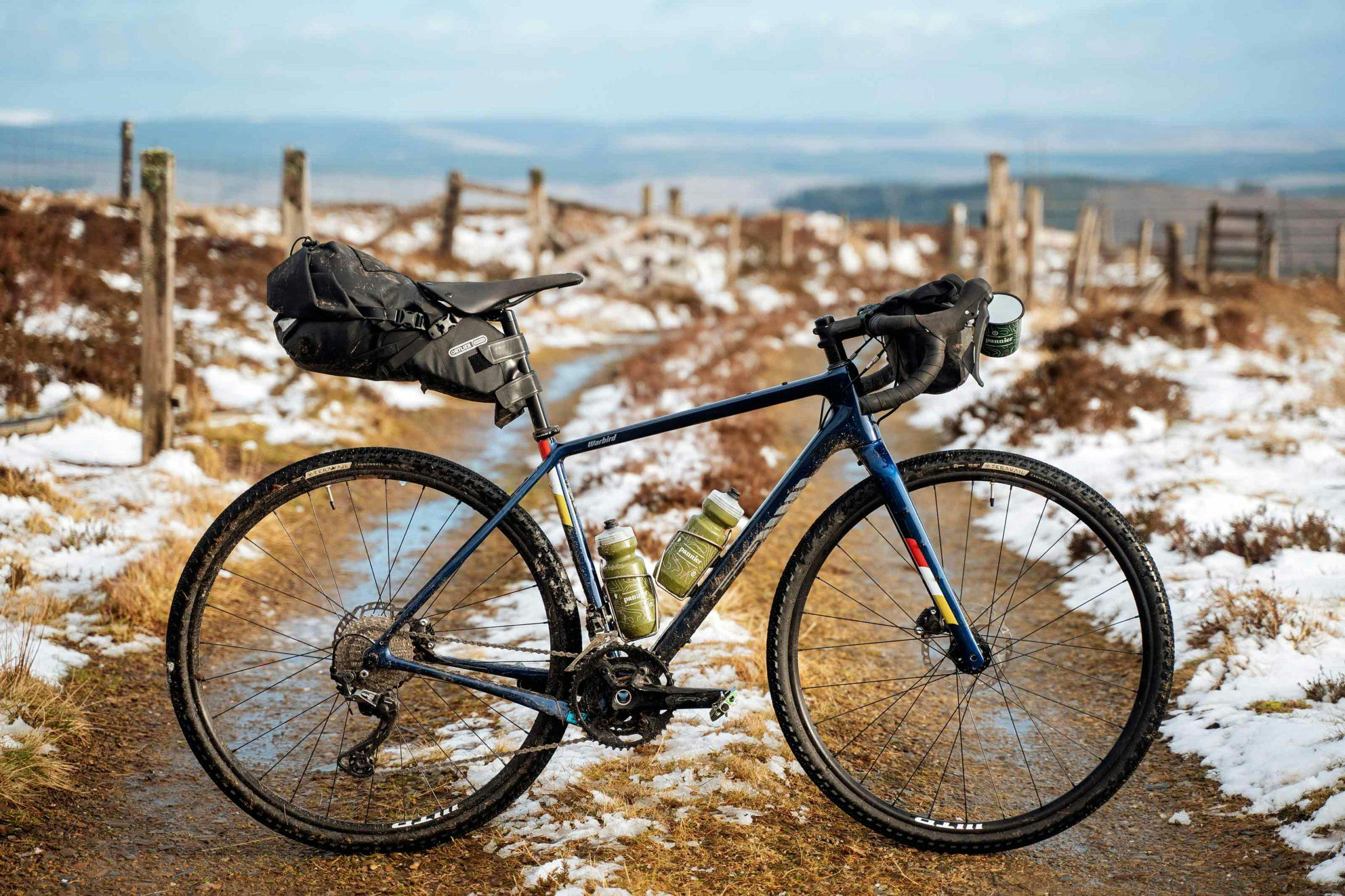
Over OS maps and drinks, we went through the next 2.5 days’ rough plans and route. Two overnight stopovers, a GPX, and trains back home from Newcastle were all we had locked in. At first light, we’d leave the cosy cabin and make our way to east, to the North Sea. Joining Duncan (photographer) and I were Dave, Tom, and world-record-seekers Ede and Jaimi. Andy would see us off, before heading home. Whilst the focus for this trip was to document the Frontier300, we were also using our long days on the bikes to get to know Ede and Jaimi, curate interviews, and also a Journal on the Salsa Warbird – seen by many as the original ‘gravel’ bike.
Analysing the wider map, and the stark ratio of north/south vs. east/west infrastructure is highlighted more than anywhere I’ve seen. Bypassing the border region north/south? Easy. Yet, try weaving your way laterally across the island and you’ll find a distinct lack of roads, and an array of alluring terrain and physical boundaries – it just so happens that these circumstances make for an ace, challenging, off-the-beaten-track bikepacking route. Zooming in, and standout sections appeared to be the high moorlands of Eskdalemuir and forestry sections of Ae and Kielder. One thing is for sure: Tunnocks tactics would need some thought as villages, stores and cafes were somewhat sparse…
Riding with Ede and Jaimi – two potential world-record holders by this time next year – sunk-in slower than my tyres in these borderland bogs. Even after spending our few days together, unless you knew, you’d be hard pressed for them to let on their palmares. Both modest hitters in their own right, Ede Harrison is a winner of both Transcontinental and Transatlantic Way Races [Women], and Jaimi Wilson has spent years touring around the world by bike. Try keeping up with them on tarmac, and you’ll soon notice – “so, where was the hill?” muttered Ede after riding up Winter’s Gibbet, the 2004 Hill Climb Championship climb. Both Ede and Jaimi are preparing for cycling world records this summer (2020) – the Trans-European and Round-the-World records, respectively. [Note – their plans for this year have been somewhat curtailed, due to Covid-19. Watch this space, though – ed.]. You can read about their plans, motivations and riding backgrounds in more detail here, and the Salsa Warbird Journal here, over the course of the next week or two…


“Even for a borderer it goes against the grain to leave a warmish house and ride out into a rainstorm. If the downpour comes gradually, introducing itself with sporadic drizzle before the incessant chatter of rain and hail, the mind and body can adjust to the inescapable companionship of the elements … Adaptation is more a question of habit than equipment.”


Following a dawn wheel-dip in the Irish Sea at Rockcliffe Beach, crunching our way over the shell shingle beach, we set off east across the Solway plain – discovering a flowy but damp Dalbeattie forest, dashing through Dumfries, and turning the pedals through the towering turbine strewn Ae forest, before heading up into the Eskdale and Langholm hills. We roamed like Reivers, “passing as freely as otters … along the quiet stretches”; albeit along our set route-line and only plundering from our own bags for snacks and storm-wear. Rather than estate or farm raid targets, we had our own series of target routepoints to hit – forestry cafes, snow-drifted summits, Tibetan temples. Staged breakdowns were so important on rides like this. Ede and Jaimi were used to the mental essentials of breaking a day down into manageable chunks, and checking stats. No more so required than for challenging, repetitive racing days on the bike.
Border Reivers were essentially bandits…who“first emerged in the 14th and 15th centuries, at about the same time as the Clans of the Scottish Highlands” and lasted until the 18th century, when the concept of a national frontier ceased. A product of the border wastelands and lack of governance, the Border Reivers “blighted the life of the whole area.” Nationality was left aside – “they were Scottish when they will and English at their pleasure; fungus which thrived on the blood sodden moors of the anglo-scottish strife” – as they earned a living plundering from anyone outside their own direct family , stealing cattle and kidnapping. A Reiving expedition was a once-in-a-lifetime adventure and a rite of passage and, whilst March/Border Laws were introduced in 1249 to offer some kind of domestic policing and a set of procedures for recovering stolen goods, “for all the aggravation fear and suffering it caused, it allowed a particular Society in a remote impoverished region to survive for many centuries”. Reiving was accepted as a way of life.

“We roamed like reivers, passing as freely as otters … along the quiet stretches; albeit along our set route-line and only plundering from our own bags for snacks and storm-wear.”


Garrowgill, amongst her ruins and steep-sided valleys was the first outlying point I felt Reivers might have sited a lair – needing “long views in two directions along the valley, and yet be practically invisible”. According to the information board at the ruin (supposedly an old shepherd’s dwelling), whilst this corner of Moffatdale now seems remote, at one time tracks and paths criss-crossed the hills and glens, busy with drovers and pedlars travelling between settlements. It was followed by a note about how bleak the weather can get amongst these hills, and the more time we spent here, the less I could quite imagine the life of a roaming Reiver here – “lurking and plotting mischief” in these wild, weather-ed border badlands. “Even for a borderer it goes against the grain to leave a warmish house and ride out into a rainstorm. If the downpour comes gradually, introducing itself with sporadic drizzle before the incessant chatter of rain and hail, the mind and body can adjust to the inescapable companionship of the elements … Adaptation is more a question of habit than equipment.”
‘Blind Roads’ was a term I grew fond of from Robb’s book, whose variety of upland way was defined by early folk: “tracts so slightly marked by footsteps that it can but be traced by a slight shade of verdure from the darker heath around it, and, being only visible to the eye when at some distance, ceases to be distinguished while the foot is actually treading it”. I’ve spent my fair share of riding career hiking blind roads, and funnily enough, there was no escape route out for us here other than a decent stint of hike-a-bike up onto the wide open snowy grouse moorlands and the highpoint of the whole route (530m) – joining an ancient track that ran to Moffat, and a fun, fast, dusky descent to Eskdalemuir.

Blind Roads [n.]
…tracts so slightly marked by footsteps that they can but be traced by a slight shade of verdure from the darker heath around it, and, being only visible to the eye when at some distance, ceases to be distinguished while the foot is actually treading it.




Eskdalemuir comprises of these stunning moorlands – the highlight section of the route, for me – and a small village, most notable for the Weather Observatory, and the Samye Ling Tibetan Buddhist monastery. Yep, look it up. We were told it was the wettest place in the world, or some sweeping statement along those lines. Low and behold, it does hold the UK weather record for the highest rainfall in a 30-minute period – 80 mm – recorded in June, 1953. It also holds the record for the dullest summer month; only 43.9 hours of sunshine were recorded in August 1912. A rapid road ride through the picturesque confluence of the Black and White Esk rivers, and we were in Langholm just before nightfall for an Inn meal, drinks, rounds of Shithead, and bed.
140kms down.


Snow fell and settled hard overnight. From Langholm, we were heading to Northumberland National Park – crossing the border proper through Kielder Forest, and remaining in England for the rest of the tour.
Robb suggests that this Anglo-Scottish border is probably the oldest national land boundary in Europe, based on physical geography – “it followed streams and rivers, ran over named passes and peaks, and along main watersheds” – the most basic, apt, and manageable way of dividing land. After the death of Queen Elizabeth, a union of Crowns was initiated by King James and the “border itself … ceased to exist as a national frontier in 1707 when England and Scotland had become the kingdom of Great Britain”. The only divide we noticed on our ride, was the astonishingly abrupt change in accents – an immediate change between Scottish in the west, to English further east, as the border line shimmied north to Berwick-upon-Tweed. Nothing else was different – the sameness of riding, of landscape and, according to Robb “this sharp divide in accent has no social equivalent” either.
In 2013, “for the first time in more than 300 years, the Borderlands felt the tug and pressure of the two great Nations on either side” during the Scottish Independence Referendum. “In living memory the national border has never been so important and it was only now that it became obvious how many British people had no idea where it ran…”


From Galloway to the gallows, we were now high and exposed near the village of Elsdon, in the shadows of Winter’s Gibbet to spend the night at a rather special Frontier Farmhouse B&B. 225kms down. Over a delicious dinner around their vast table, the Kennys – farmers, and hosts – shed light on the area, life as a frontier farmer, and their Common Riding experiences with groups of North Americans they organise package tours for. We discussed guest’s idea of remoteness – not being able to ‘quickly nip to the shop or the pub’ … before conversation quickly turned to Ede and Jaimi’s efforts, and it was special to see folk interested in, and excited by bike travel. Georgia and her young son even came to cheer us on at the summit of Winter’s Gibbet the following morning, vowing to keep tabs of their records. I feel like Ede and Jaimi both inspired a couple of people along the way on this trip, and this was just the start.
The lone gallows, that once publicly shamed William Winter for killing Margaret Crozier in 1792, signalled the last challenging section of riding on the route – through Simonside Forest, before dropping down through the suburbs to the coast … and civilisation once again.
300kms down. And out.


“In living memory the national border has never been so important and it was only now that it became obvious how many British people had no idea where it ran…”

In The Debatable Land, Robb refers to “nothingness, but everythingness” and it struck me as the best summary of this region of the UK. Sure, there is a distinct lack of typical guidebook sites and sights, but losing ourselves amongst these glorious frontier lands was all you want and need from an escape by bike. Go visit the Kennys at Ravenscleugh Farm, and scribble the Langholm Common Ride and Frontier300 event onto your calendar…
Look out for the Meet Ede & Jaimi and Warbird: the flight of the original gravel bike Journals on Pannier soon, and the Frontier300 event in June 2020 [Note – now postponed until 2021 – ed.]…
Photography
Duncan Philpott
Words & Illustration
Stef Amato
Tourers
Ede Harrison
Jaimi Wilson
Tom Hill
David Sear
Stefan Amato
Duncan Philpott
References
The Debatable Land – Graham Robb
Overnights
Eskdale Hotel, Langholm
Ravenscleugh Farm, Elsdon

